Marine navigation has evolved far beyond paper charts and standalone GPS devices. Today’s boaters expect more from their tools, especially when using smartphones and tablets to plan trips and navigate waterways. A modern navigation app is no longer just about showing your position, it’s about providing a complete picture of the surrounding environment.
With so many options available, boaters often search for the best marine navigation app to find tools that combine accurate charts, real-time data, and ease of use into one reliable platform.
Core features every navigation app should have
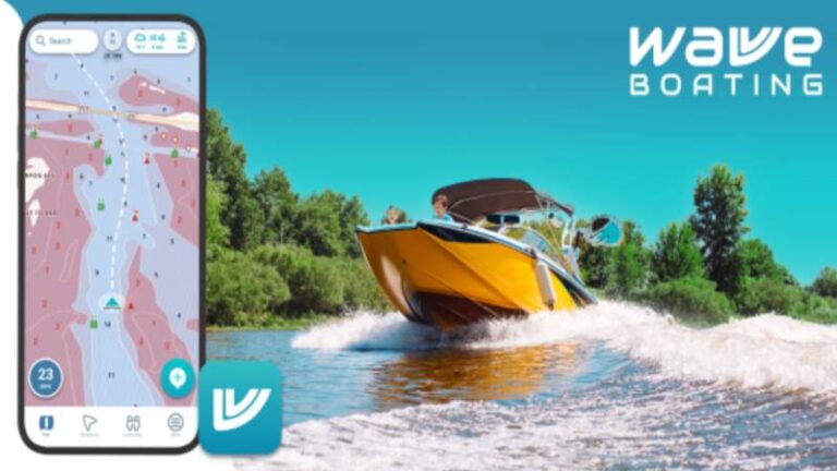
The foundation of any marine navigation app is accurate chart data. Digital nautical charts display water depth, navigation markers, hazards, and coastline features. These charts help boaters understand where they are and what lies ahead.
Many of the top apps today include advanced chart features such as depth shading, sonar overlays, and customizable map layers. These tools allow users to visualize underwater terrain more clearly and make safer route decisions.
In addition to charts, GPS positioning is essential. Real-time tracking shows your exact location on the water, helping you stay on course even when landmarks are not visible.
Route planning and navigation tools
One of the biggest advantages of modern navigation apps is route planning. Boaters can create routes, mark waypoints, and estimate travel time before leaving the dock.
Some apps also offer automatic routing, which suggests safe navigation paths based on chart data and known hazards. These tools are especially useful when exploring unfamiliar waterways or planning longer trips.
Planning ahead reduces stress and allows boaters to focus on safe operation while underway.
Real-time environmental data
A great navigation app goes beyond charts by integrating real-time environmental data. This includes weather forecasts, tides, currents, and sometimes wave conditions.
Having this information directly on the map helps boaters understand how conditions may affect their route. For example, strong winds or changing tides can influence the safest path or best time to travel.
Many modern apps combine all of this data into one interface, making it easier to make informed decisions on the water.
Offline access and reliability
Connectivity is not always reliable on the water. That’s why offline functionality is a key feature of high-quality navigation apps.
The ability to download charts and access navigation tools without an internet connection ensures that boaters can continue navigating safely even in remote areas.
Reliable performance is just as important. Apps should load quickly, respond smoothly, and remain easy to read in bright sunlight or rough conditions.
Ease of use and clear design
One of the most overlooked features of a navigation app is usability. Complex charts and cluttered interfaces can make navigation more difficult, especially for beginners.
Modern apps are designed with simplicity in mind. Clear visuals, intuitive controls, and easy-to-read maps help boaters quickly understand their surroundings.
This is especially important when quick decisions are needed, such as avoiding hazards or adjusting course.
Community and shared insights
Some navigation apps now include community-driven features. Boaters can share routes, mark hazards, and recommend locations such as anchorages, marinas, or fishing spots.
This shared knowledge adds real-world context that charts alone cannot provide. It can also help boaters discover new destinations and avoid unexpected issues.
However, it’s important to treat community data as a supplement rather than a replacement for official chart information.
Why modern apps are replacing traditional tools
The rise of mobile technology has made navigation apps more powerful than ever. Smartphones and tablets now have high-resolution displays, built-in GPS, and the ability to run complex navigation software.
Because of this, many boaters now rely on apps as primary navigation tools or as backups to onboard systems. These apps are portable, affordable, and constantly updated.
In fact, it’s becoming increasingly common for boaters to use both mobile apps and traditional chartplotters together for added flexibility.
Choosing the right app for your needs
There is no single app that works best for every boater. The right choice depends on how and where you boat.
Some boaters prioritize simple interfaces and quick planning tools, while others prefer detailed charts and advanced navigation features. The best approach is to choose an app that fits your routine and provides the information you need most often.
Navigating with confidence
Modern marine navigation apps are transforming how people explore waterways. By combining charts, GPS, weather data, and planning tools into one platform, these apps make boating safer and more accessible.
Understanding what features matter most helps you choose the right tool and get the most out of your time on the water.
With the right navigation app, boaters can plan smarter trips, avoid hazards, and navigate with greater confidence every time they head out. See more.